Re-Thinking Land and History: Working with Navajo Mountain Soil Water Conservation District Members
Diné lands were intentionally chosen for development interventions by soil scientists and Federal administrators. By 1937 the Bureau of Indian Affairs (BIA), a branch of the Federal government, had already implemented a few rounds of voluntary livestock reduction in the Navajo reservation to mitigate overgrazing and soil erosion. Livestock reduction was justified on the belief that Diné livestock practices were to blame for soil erosion and silt accumulation in the Hoover Dam (originally called Boulder Dam). After 1937, more rounds of livestock reduction were imposed on Diné people and plans to compensate them for their loss of livestock income failed. Livestock reduction increased poverty in the Navajo reservation and increased pressure on Diné to seek wage work rather than traditional subsistence practices that provided a cushion of independence. Diné pushed back against the reduction but the psychological, spiritual, and economic damage continues today. As an historical event retold by elders, Diné today draw upon it to understand the world and it serves as a warning toward government overstepping its authority. As a Diné PhD candidate, the livestock reduction influences my research question regarding Diné lands, development, and sovereignty. These themes are articulated together by Diné people, elected officials, and administrators in formal and informal meetings. Land development and political questions about land use are conjoined by depoliticized discourses about soil erosion, livestock units, and range management. Thus, political questions about land are naturalized by scientific measurement. This emerged from the historical soil investigation and experiment conducted in the Navajo Nation.
During the livestock reduction, the BIA sent out soil technicians into the Navajo Nation to study the health of the soil and current land practices. These soil technicians were the vanguard of the US Department of Interiors Soil Erosion Service (SES) and the subsequent US Department of Agriculture Soil Conservation Services (SCS). These technicians created soil laboratories and demonstrations to measure the soil as well as teach Navajos about soil use and degradation. Additionally, the SCS produced land management surveys that were housed at University of Arizona’s Special Collections and University of New Mexico’s Center for Southwest Research and Special Collection. In each report, Diné land was categorized as ‘inaccessible and barren’, ‘waste’, ‘mountainous’, or ‘area producing run-off’. Except for the names of Diné land users, Diné people, histories, and cosmologies were absent in the soil studies. The data collected in each report was geared towards identifying sites of intervention to make land and soil more productive and economically valuable.
The vocabulary of land productivity and value parallels the Federal government’s attempts to transform Diné livestock owners either into small farmers or wage workers during this time of livestock reduction. SCS prioritized land and soil improvement that could be accomplished by water management. The engineering report for Tonalea (Tó Nehelį́į́h) advocated for irrigation projects that included dams, dikes, sand fences, and wire rocks to control water flows and flooding that would increase farming lands and make them more productive with rational water use.
Without historical context, these land management surveys read as disinterested and interconnected reports of the US Department of Agriculture’s Soil Conservation Service. Each Navajo land survey opens with a heavy description of the site; telephone location, roads, water flows, vegetation, rodents, family sizes and numbers, livestock capacity, cultivated lands, farming methods, wage work, typologies of land, and climate. These descriptions are directed towards identifying a plan of intervention on behalf of the Diné people by the Federal government. A picture is created using these descriptions with a focus on land improvement –Diné land emerges as an object of study and intervention in these land management reports.
The reports conducted on my community felt distant despite my recognition of the description of geographic features, community buildings, and roads. I spent time at the University of Arizona Special Collections archive looking at 1930s’ Navajo land management surveys. The written findings from these land management surveys incorporate engineering studies, land planning reports, range management reports, agronomy reports, and sociological surveys of different Diné communities. After sharing what I found in the archives, the maps were of great interest to other Conservation District members. They were interested in connecting local histories to the land management surveys by locating some sites designated for improvement projects.
Each community survey read like echoes devoid of life and experiences that are tied to places. In my meetings with Navajo Mountain Soil and Water Conservation District (NM-SWCD) members we noticed that local histories that we were familiar with were absent from the surveys. The five of us looked over the reports commenting on the writing style and data collected. The lands and communities document looked familiar and dissimilar to each of us. The members were impressed by the data and often wished they could conduct a similar survey in their communities.
In our discussions, they told local histories with traditional names for mountain ranges, washes, canyons, and valleys. Two district members, Willie Greyeyes and Betty Dodson, talked about a map of a farming area near Shonto that was included in land range management surveys (See map 1). With the help of the district members, I quickly sketched the surrounding area with the names of the canyons while talked about the local histories of these canyons that included the direction of water flow, family settlements after the 1864 Long Walk, early traders (S.I. and Cecil Richardson and the Wetherhills), other tribes (Paiutes), and Diné cosmologies (See Sketch 1). With the help of my very rough sketch, the land survey farming map felt more familiar to them. This prompted me to think about the local histories and traditional geographies that were absent which made these land survey maps feel distance and alien.
Furthermore, I visited two sites from the land management surveys, Tonalea (Tó Nehelį́į́h, “where the water emerges/collects) and Cows Springs (Béégishii Bí Tó). In my search for these sites, I was joined by Vicki Kee, a Navajo Mountain Soil and Water Conservation District member (NM-SWCD). Tonalea is one of three districts where I plan to find land improvement sites, along with Shonto and Kayenta. We drove through dirt roads passing homes and corrals looking for signs of the SCS project. The first site we searched for was four miles south of the old trading post. There was no map of this site but the surveys provided a description that we followed. After following the direction of Vicki Kee, we found that the site is located in the Hopi Partitioned Lands (HPL), a land status that emerged from the 1974 Navajo-Hopi Land Dispute. It was covered by overgrown vegetation and required four-wheel drive. We found dikes that had been built to divert water away and stop the flooding of crops. Vicki Kee told me that Diné families used to live and farm in the area until they were relocated because of the land dispute.
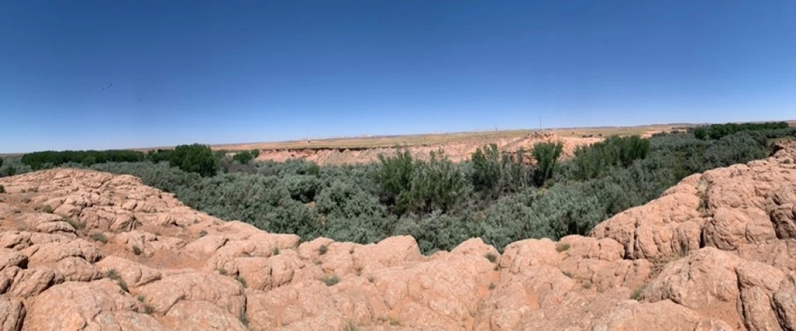
I also visited Cow Springs (Béégishii Bí Tó) to find any signs of the Cow Springs Irrigation Project proposed in the land management survey (see map 2). Cow Springs is located seven miles northeast of old trading posts along US-160. The next stop was finding any signs of the Cow Springs Irrigation Project proposed in the land management survey. Cow Springs is located in Navajo Partitioned Lands (NPL), another land status created the Navajo-Hopi Land dispute. The project proposed building a dam with a spigot to provide water for the farms south of the springs. This would have increased the number of productive lands and the crop production of farming lands. But this project proved difficult because the whole area was overgrown with invasive tree species that inhibited travel (see photo 1). The spring and lake were dried out. No such dam was found but there were other earth dams with unknown origin dates. We speculated that the dam may have been built but was destroyed with the construction of the railroad that would transfer coal from Black Mesa to the now-demolished Navajo Generating Station. This railroad was built in the 1960s because of the controversial Peabody Coal mining project in the Navajo Nation. The railroad cuts through where the proposed dam was located.
Working with the Navajo Mountain Soil and Water Conservation District and the Land Management Surveys, my research unpacks the political history of Diné land and soil through development projects. The land management surveys tells one side of history. I am interested in connecting local histories to the archived land management surveys to produce local histories from the NM-SWCD perspectives. This connection is important to me because it reveals a complex political history that is obscured by these soil maps devoid of Navajo participation and meaning. NM-SWCD provided great insight into what was missing and how these maps could be repurposed for benefit of Diné. The NM SWCD district members noted that such history would be beneficial to younger Diné interested in local history, soil science, agriculture, or livestock.
The group meetings where we examined maps revealed the lack of Diné geographies and histories that made each community familiar and complete. Willie Greyeyes and Betty Dodson added to the maps a sense of history, experience, and practice that was absent. In exploring old sites of SCS projects with Vicki Kee, the local history of Tonalea and Cow Springs became entwined with the materiality of old and missing infrastructure. The infrastructure of dikes in the first site prompted discussions between Vicki Kee and I about unused farm areas, relocated families, and emotions associated with the land dispute. The missing, or perhaps never built, Cow Springs dam infrastructure prompted discussions of the land dispute, water storage, fishing, climate change, and coal leases and mining. The SCS projects were oriented towards framing, planning, and intervening in Diné communities – now eighty-six years later they are part of a layered history of land dispute and management. The SCS projects made Diné lands and soil into objects of study and intervention with intended ideas of future use. But a land dispute altered where Diné would be living, what lands were considered Diné, and added additional layers of institutional arrangements in Tonalea. The Cow Springs area and accompanying development plans are shaped by the history of coal extraction.
I plan to conduct more visits to mapped areas and sites of agricultural development in the land surveys accompanied by NM-SWCD members. Additionally, I am interested in exploring the possibility of creating maps with the NM-SWCD members that include traditional Diné names of geographic features.
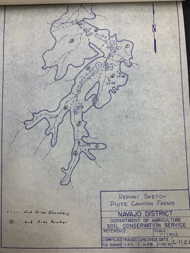
Map 1: Piute Canyon Farms (Moyles, 1938)
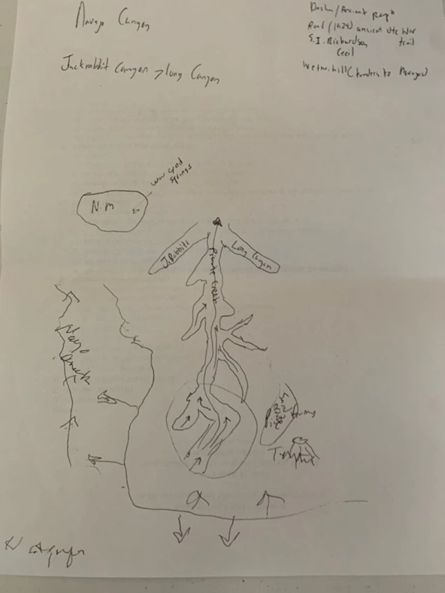
Sketch 1: Sketch of Canyons created with Willy Greyeyes and Betty Dodson
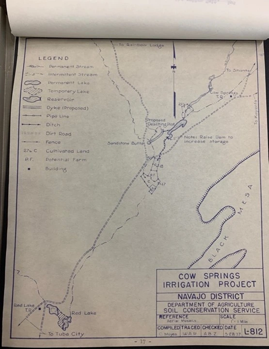
Cow Springs Irrigation Project Map, (Moyes, 1937).
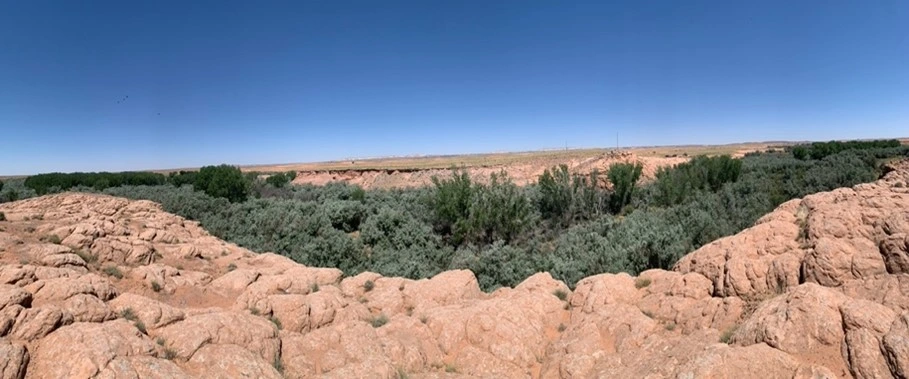
Photo 1: Cow Springs, Navajo Nation
Moyes, C.L. (1937a). Engineering Report Unit One. Reports of a Land Management Survey, Navajo Reservation (Box 1, Folder 1). University of Arizona Special Collections, Tucson, Arizona.
Moyes, C.L. (1938). Engineering Report Unit Two. Reports of a Land Management Survey, Navajo Reservation (Box 1, Folder 1). University of Arizona Special Collections, Tucson, Arizona.