About - Temperature and Precipitation:
Hot and dry. The Southwest is hot, in part, because it is dry. The region’s subtropical latitudes mean greater access to incoming solar radiation as compared to points to the north, but it is the region’s lack of atmospheric moisture that maximizes the effect of the Sun’s energy. Clouds reflect incoming radiation, and water at the surface absorbs its energy, evaporating, and carrying it away as latent–literally “hidden”–heat. With clear skies and dry ground, sunlight heats the land surface efficiently, and so we will see daytime high temperatures sometimes in excess of 120°F in the low Arizona deserts, while wetter, cloudier places nearer to the equator may rarely see 100°F despite even greater potential access to the Sun’s energy. Exposure to increased temperatures, especially during the summer months, can have negative impacts on health. Extreme heat poses serious health risks, particularly for vulnerable populations such as the elderly and those with pre-existing health conditions.
But hot and dry is not the whole story. Nighttime cooling proceeds more efficiently under clear, dry skies and low relative humidity; morning low temperatures can drop to 50-60 degrees (F) cooler than the daytime maximum temperature. The cool season (roughly October through March) brings storms fueled by cold air borne along by waves in the westerly jet stream–troughs and cutoff lows that sufficiently stir the air to convey moisture from the Pacific Ocean, sometimes tapping into so-called “atmospheric rivers” of tropical moisture. The winter storms produce cold fronts that leave cold, dry air in their wake, leading to the region’s most pronounced cold spells. Monsoon moisture in the summer brings rain–or at the very least, clouds–, limiting daytime high temperatures; the longest stretches of extreme heat occur in years when the monsoon arrives late. These years often coincide with increased heat-related illnesses and deaths.
Temperature and precipitation vary with elevation, and this is a potent driver of differences in climate from place to place in the Southwest. Temperature can decrease by as much as 5.5°F for every 1000 ft of elevation gain, and elevations in the Southwest vary from 141 ft in Yuma, AZ to 13,161 ft at Wheeler Peak in northern New Mexico. Average monsoon rainfall totals in the Yuma area are about 1 in, while Flagstaff, AZ (elev. 6,909 ft) receives close to 8 inches, on average. Estimates of average monsoon rainfall totals for the Chiricahua mountains (Chiricahua Peak elev. 9,773 ft) exceed 20 inches. In the cool season, Yuma typically receives an additional 2 inches of precipitation, while Flagstaff can expect around 13 inches. Santa Fe, NM, despite lying at elevations comparable to Flagstaff, receives an average of around 5 inches of monsoon rainfall and around 4 inches of cool-season precipitation.
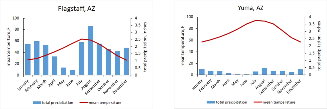
The average monthly precipitation and temperature for Flagstaff and Yuma illustrate the range of climate conditions resulting from differences in elevation.
Links / Resources:
- Climate Data and Graphs for climate stations in southern Arizona
- PRISM gridded climate data, daily and monthly average temperature, total precipitation, and more, time series and 30-yr averages
- Arizona Department of Health Services Extreme Heat Website
- New Mexico Environmental Public Health Racking for HRI