Climate and Water Resources of the Chuska Mountains
In the fall of 2015, I began working with the Navajo Nation Department of Water Resources, Water Management Branch, to address water resource management questions they had for the Chuska Mountains. These mountains are the only native headwaters on the Navajo Nation, where water scarcity impacts Navajo tradition, culture and livelihood. Since our initial discussions, Water Management Branch staff and I have collaboratively developed guiding research questions about past changes in water and climate.
Our first field expeditions explored the landscape of the Chuska mountains so that I could better understand this unique place and its importance to the Navajo people (Photo 1). My guides were Carlee McClellan and Irving Brady from the Water Management Branch and Crystal Tully-Cordova and Lani Tsinijinni, both Navajo PhD students working on modern water in the Chuska Mountains. They helped me stitch together an understanding of this hydroclimatic system, as well as help me visualize Navajo agricultural and traditional ties to the place.
My project is guided by the Navajo water managers’ interests and concerns. My research background drives our approach to investigating their questions. For this reason, I am following a two-prong strategy to try to answer questions of snow and surface water changes in the past. First, I am using tree rings and Navajo snow records to reconstruct Chuska snowpack prior to the last 30 years of instrumental records. Second, I am using satellite imagery to develop a baseline record of surface waters in the Chuskas for the last 30 years.
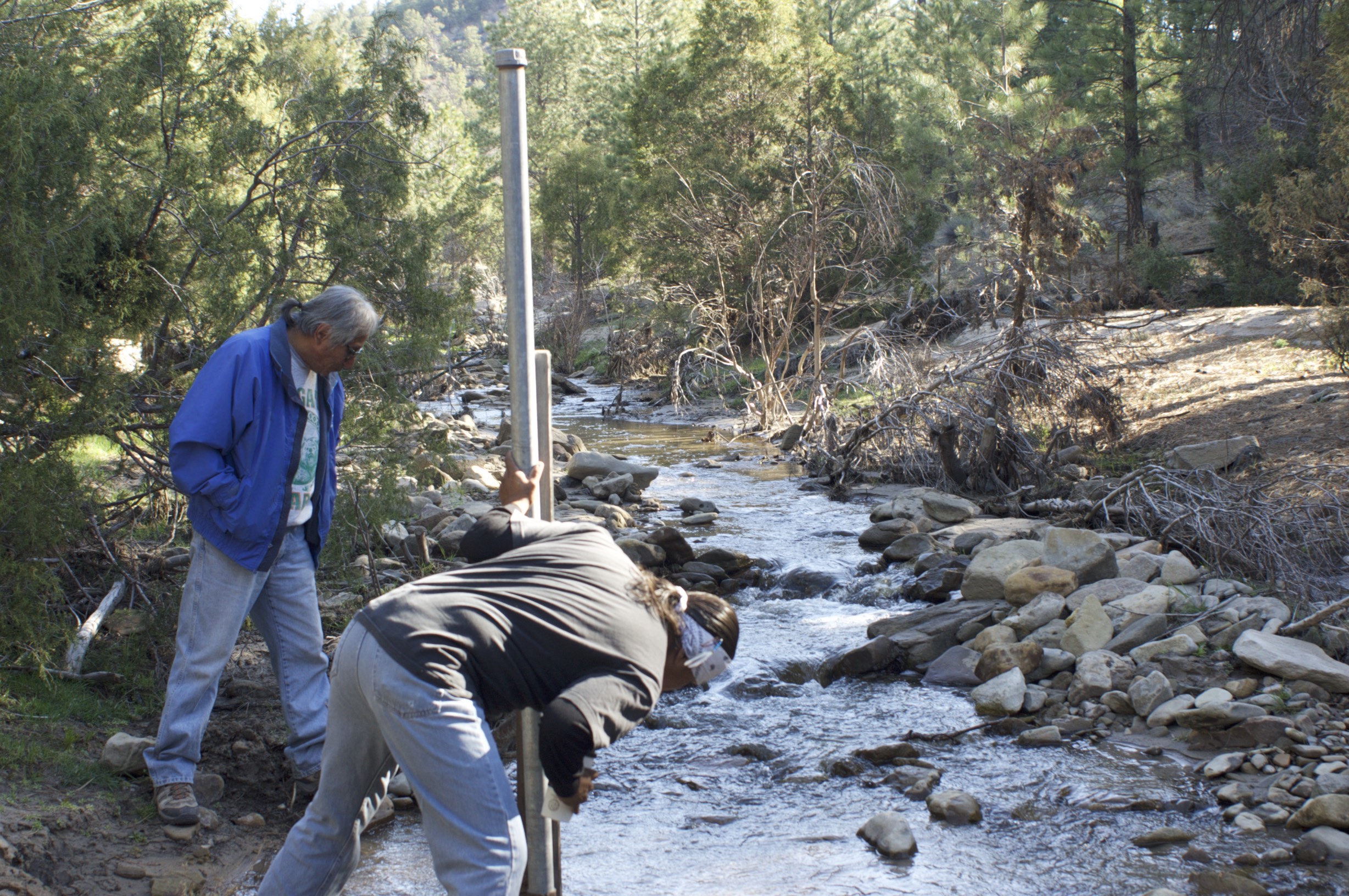
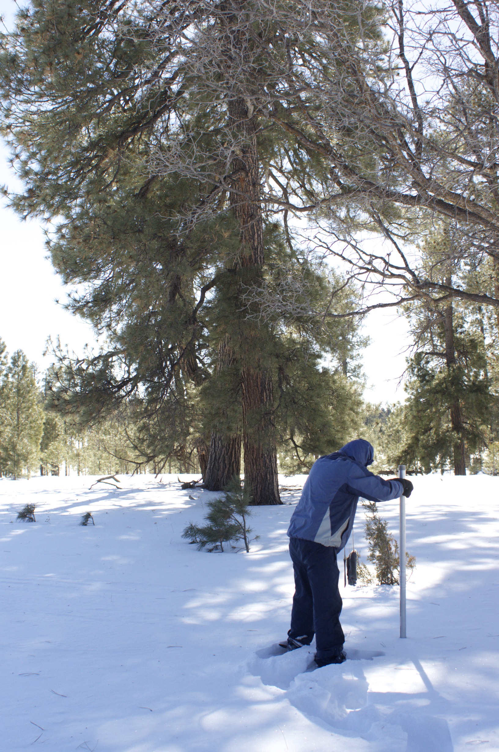
Photo 1 Navajo Water Management Branch field technicians Irving Brady and Ralphus Begay collect streamflow data for Whiskey Creek, Navajo Nation
Photo 2 Irving Brady demonstrates the use of a snow corer to sample snow pack. Snowpack snow water equivalent is determined from the weight of the snow sample in the tube. Staff at the Water Management Branch collect these data bi-monthly from January to April.
Gaining a Long-term View on the History of Snow
After initial analysis of the relationship between regional tree-rings and Chuska snow, it became clear that a strong connection exists between climate information contained in the rings and Chuska hydroclimate itself. This connection can be exploited to reconstruct past hydroclimate. However, to take advantage of the limited time period covered by the snow data, we concluded that we needed more current tree-ring records (Photo 2).
In January, buoyed by support from the Climate and Society Fellowship, I planned a field campaign to collect tree samples on the Mogollon Rim in northcentral Arizona. The goal of the field campaign was to update sites that showed a strong relationship with Navajo snow, and to supplement tree-ring records currently under development collected from the Chuskas. The Mogollon Rim experiences similar winter weather patterns as the Chuska Mountains. These patterns are reflected in regional SNOTEL and snow course site records. The existing Mogollon Rim tree-ring records were too short to cover the last three decades, an important hydroclimatic period because it overlaps with the Chuska snow data and because it captures a period of known hydroclimatic extremes in the region.
I felt excited anticipation about conducting fieldwork in higher elevations in winter, yet unsure about temperatures and snow depth. These uncertainties weighed on my mind as I traveled to Tucson to collect increment borers, sample straws, GPS units and, most importantly, my invaluable field crew Dr. Paul Sheppard and Alex Arizpe, from the Laboratory of Tree-Ring Research (Photo 3). Our destination was the area around the San Francisco Peaks, Arizona, where dendrochronologists collected tree-ring samples in the 1980’s. Our mission was to return to these notable sites and core new trees storing information for the last 30 years. Our first stop was a pinion-juniper woodland near Sedona, Arizona, under overcast skies following a day of rain but no snow. The pinion trees were young and middle aged. This would be our only time in the more arid setting typically found with the pinion-juniper forests because the next three field sites were in the dry, park-like Ponderosa pine forest around Flagstaff, ARizona. We cored Ponderosa pine trees at Sunset Crater, Robinson Mountain nearby, and further to the west at Slate Mountain. Our final stop was snow-covered and at higher elevation in the cooler, denser Douglas fir forest of the San Francisco Peaks. There we found the snow and needed to post-hole in thigh-deep snow looking for promising trees to core.
Our two-day field campaign was successful! We returned to Tucson with 107 tree cores from 55 trees and 5 sites (Photo 4). Though I am still finalizing dates on the rings, at least one core dates back to 1636. Mounting, sanding, counting, dating and developing an updated site chronology for each site is now nearly completed. Soon, these chronologies will be ready to use as potential predictors in a snowpack reconstruction model (Photo 5).
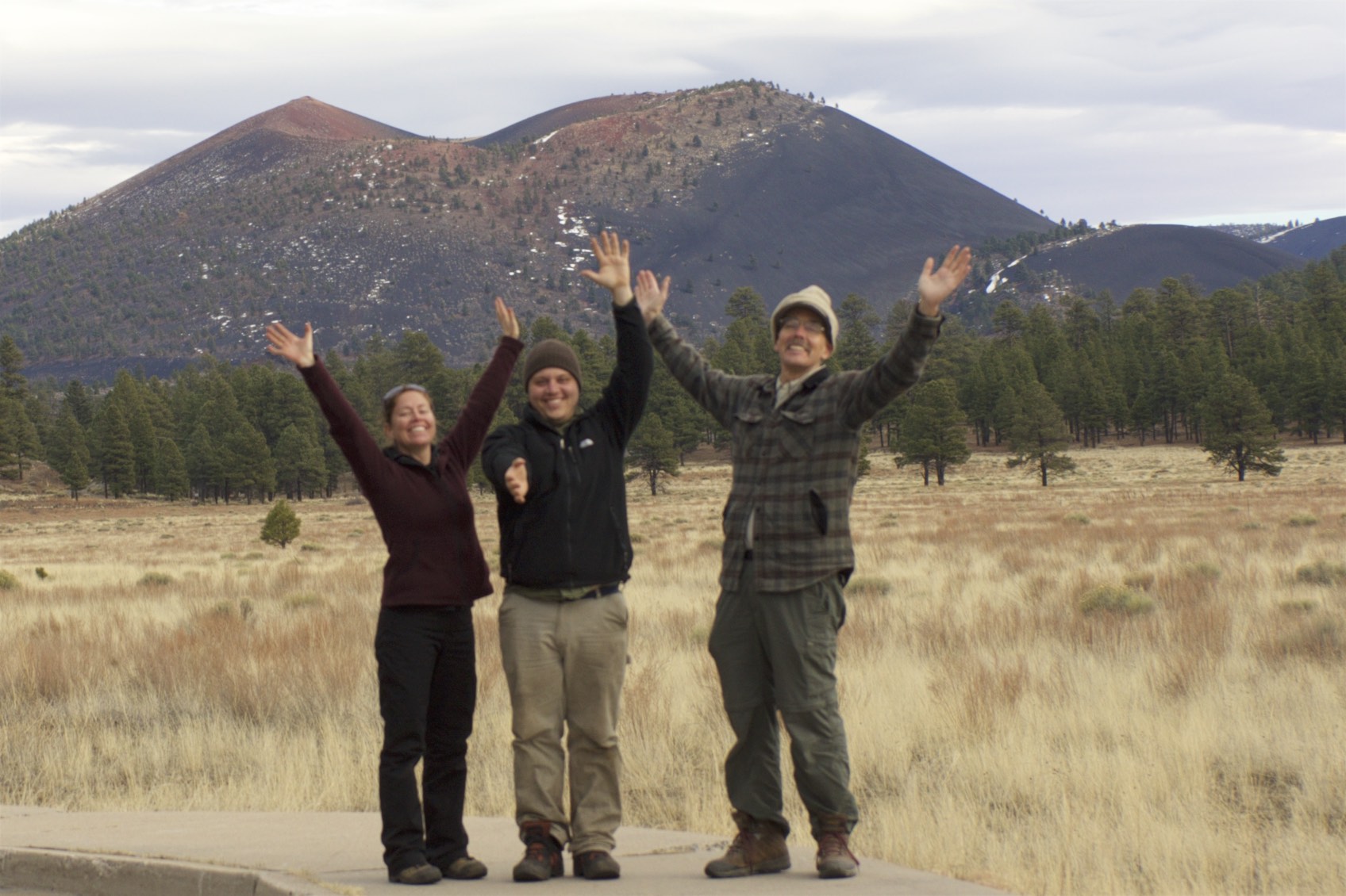
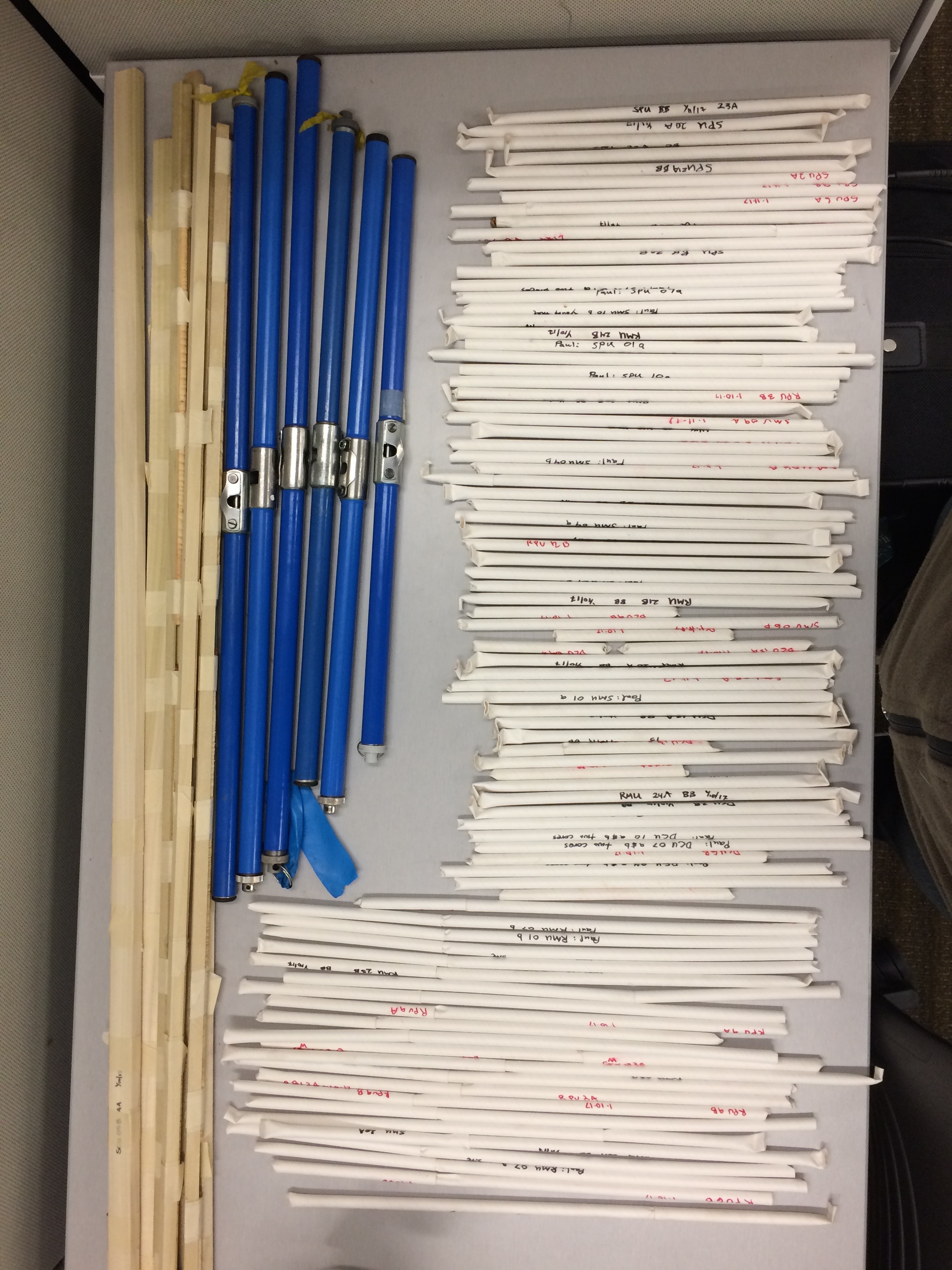
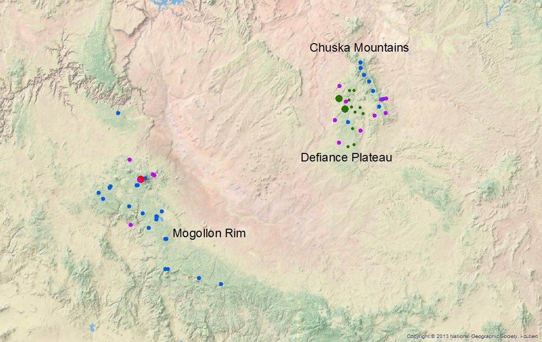
Photo 3 Becky Brice, Alex Arizpe, and Dr. Paul Sheppard stopping at Sunset Crater to collect tree cores, and photographs.
Photo 4 We collected over 100 tree-ring samples from the Mogollon Rim, Arizona. Dendrochronologists use increment borers to extract pencil-sized cores from trees (blue tubes). In the field, we place the fragile cores in rigid straws for transportation to the lab (white tubes). Once at the lab, we mount and sand each core for dating, measuring and analysis (wooden sticks at left).
Photo 5 Regional map of northeastern Arizona, including the Mogollon Rim near Flagstaff and the Chuska Mountains of the Navajo Nation. Blue dots show the location of snow course and SNOTEL sites. Purple dots show the location of tree-ring climate sites used for this study. Green dots are existing tree-ring ecological sites collected by Christopher Guiterman.
Watersheds and Lakes of the Chuska Mountains

Surface waters in the Chuska mountains seem to be an indicator of hydroclimatic variability. The relationship between snowpack and surface waters is a pressing question for Navajo water managers, particularly if this relationship will help them better understand mountain runoff and water supply. However, streamflow records are limited in the Chuskas, and no lake level records exist for the naturally occurring lakes. In response to these basic data needs, my collaborators and I investigated approaches to quantify surface water changes.
To reconstruct a record of changing lake surface area, we decided to use satellite imagery and focus on three of the largest naturally occurring surface waters (Photo 6). Following my initial evaluation of lake levels in the Chuska Mountains, two goals emerged. The first goal was to have a way to accurately quantify lake area. I decided to walk the perimeter of at least one lake to ground-truth lake area estimated from satellites, versus lake area measured with GPS. The second goal was to visit the study area with a focus on watershed scale, location and orientation. How does the surface water run off these mountains, and then reside, anyway? I returned to the Navajo Nation in June to accompany Irving Brady, a Water Management Branch veteran of nearly 30 years, to view the watersheds. Irving has become an essential source of expertise and guidance for understanding the cultural landscape in this traditionally important mountain range, as well as for understanding the physical landscape itself. Data collected from this field trip is still being compiled and evaluated. I’m optimistic that it will help us further define and our understanding water resources in the Chuskas.
Photo 6 Toadlena Lake in the northcentral portion of the Chuska Mountains. Toadlena Lake is one of three lakes with estimated surface area using satellite imagery.
Ongoing Collaborations with Navajo Water Managers
Collaborating with the Navajo Nation has proven to be intellectually and professionally invigorating. Partners at the Navajo Nation Department of Water Resources are supportive and have facilitated entry to essential locations in the otherwise hard-to-access Chuska range. Steep, loose and narrow forest roads necessitate an expertise unique to members of the community.
As a reciprocal effort, I have been actively sharing progress of my research through professional talks co-authored by collaborators at the Laboratory of Tree-Ring Research (LTRR), Dr. Christopher Guiterman and Dr. Connie Woodhouse, and Carlee McClellan at the Water Management Branch. In April, I shared preliminary results during the University of Arizona’s Earth Week. Colleagues at the Laboratory of Tree-ring Research, enthusiastic about this study, introduced me to new ideas and potentially different approaches to my research. I also shared these preliminary results at the Association of American Geographers Annual Meeting, Water Resources Specialty group in Boston. My colleagues in geography expanded my thinking even more broadly to thinking about the cultural landscape in combination with the physical place.
In May, I returned to meet with staff at the Navajo Water Management Branch to share what I’ve learned to this point. I developed a fact sheet to help illustrate progress on the research, to help facilitate information sharing, and to guide discussions about how the research is addressing the questions we initially chose to pursue. Water managers were interested in these preliminary results, particularly the potential to gain a historic record of lake area changes for major surface waters in the Chuskas.
The first half of the 2017 Climate and Society Fellowship has proven to be wonderfully productive and fulfilling. I am looking forward to the next six months of generating results and use-inspired products.