Southwest Climate Outlook - El Niño Tracker - November 2019
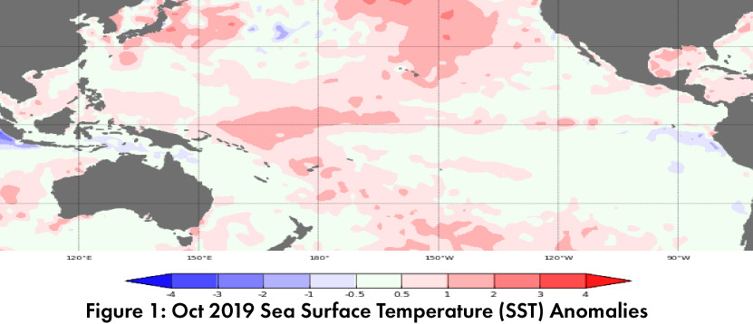
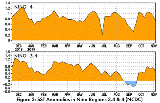
As with last month, warm waters have been lingering in the equatorial Pacific (Figs. 1-2). The consensus is on subseasonal variability and not borderline El Niño conditions, and they are expected to revert back to close to normal over winter and spring. Seasonal outlooks and forecasts all point to ENSO-neutral conditions lasting through 2019 and into 2020.
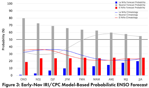
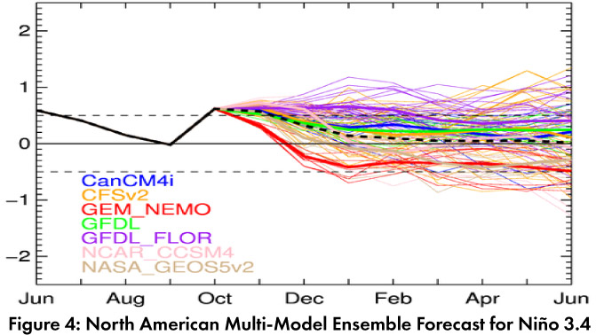
Forecast Roundup: On Nov 11, the Japanese Meteorological Agency (JMA) highlighted lingering warmer-than-normal SSTs in the western equatorial Pacific, but saw cooling subsurface temperatures, and maintained their call for a 60-percent chance of ENSO-neutral conditions to continue until spring 2020. On Nov 12, the Australian Bureau of Meteorology maintained their ENSO Outlook at ‘inactive’ noting the slightly warmer than average oceanic conditions, but with atmospheric indicators “generally neutral”. On Nov 14, the NOAA Climate Prediction Center (CPC) issued their ENSO diagnostic discussion with an inactive alert status. They noted the positive SST anomalies and adjusted their forecast chances of ENSO-netural conditions to 70-percent (winter) and 60 to 65-percent (spring). On Nov 19, the International Research Institute (IRI) issued an ENSO Quick Look (Fig. 3), noting “oceanic warming is attributed to intraseasonal variability”. Their forecasts see ENSO-neutral as the most likely outcome, but remain at “slightly higher chances for El Niño than La Niña”. The Nov 2019 North American Multi-Model Ensemble (NMME) saw a bounce back towards positive SST anomalies in October, but is generally predicted to return and remain within the range of ENSO-neutral through 2019 and into 2020 (Fig. 4).
Summary: Despite recent short term warming in SSTs, atmospheric conditions remain within the range of ENSO-neutral, and ENSO-neutral remains the most likely outcome for 2019 into spring 2020. So what does this mean for the Southwest? The short answer is, it is hard to say. ENSO-neutral winters have produced some of the wettest and driest winters (and everything in between). Rather than a signal that drags our chances wet (as with El Niño) or dry (as with La Niña), ENSO-neutral calls for equal chances of either (or just a normal winter). This means we will continue to monitor sub-seasonal and short term forecasts for insight into upcoming events, but that within the bounds of a “typical” southwestern winter, pretty much anything is on the table.
Online Resources
- Figure 1 - Australian Bureau of Meteorology - bom.gov.au/climate/enso
- Figure 2 - NOAA - Climate Prediction Center - cpc.ncep.noaa.gov
- Figure 3 - International Research Institute for Climate and Society - iri.columbia.edu
- Figure 4 - NOAA - Climate Prediction Center - cpc.ncep.noaa.gov