Southwest Climate Outlook - El Niño Tracker - November 2020
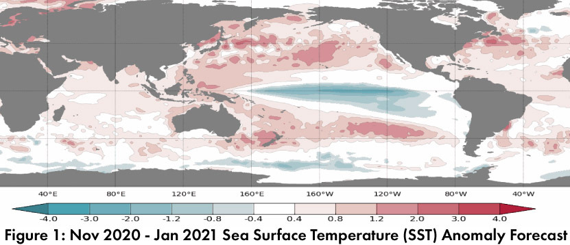
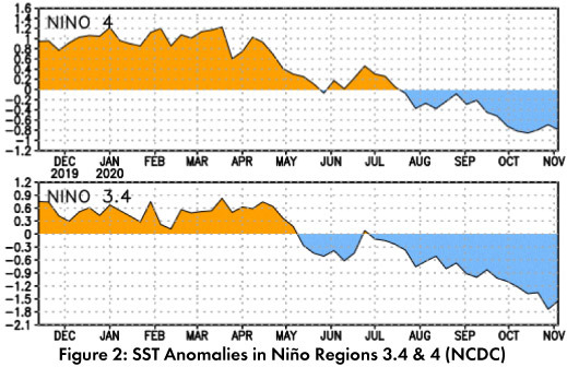
Sea surface temperature (SST) forecasts for December through February call for below normal conditions across the equatorial Pacific (Fig. 1), extending the trend of the last 3-4 months (Fig. 2). International climate outlooks describe La Niña conditions as forecast to remain a La Niña event through winter 2020.
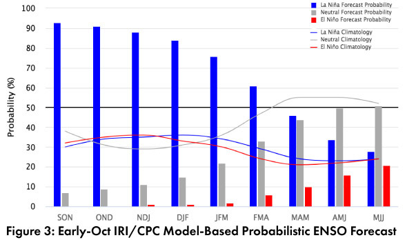
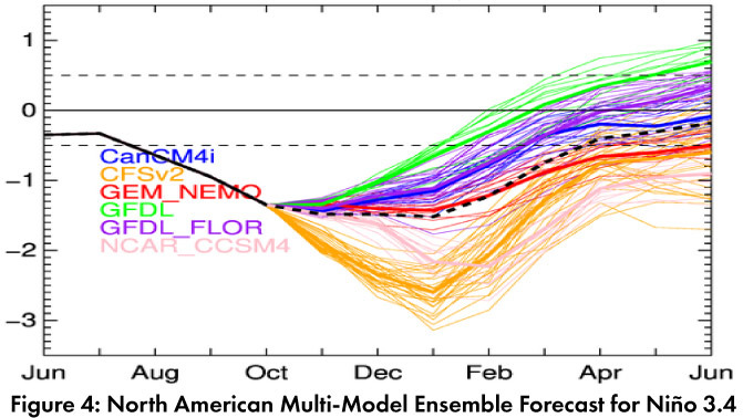
Forecast Roundup: On Nov 10, the Australian Bureau of Meteorology was at official La Niña status and noted that models still indicate the possibility of it reaching strong status, and likely to peak in Dec 2020 or Jan 2021. On Nov 10, the Japanese Meteorological Agency (JMA) maintained its forecast at a 90-percent chance of La Nina conditions to last through winter 2020-2021. On Nov 12, the NOAA Climate Prediction Center (CPC) ENSO status was at La Niña Advisory. The CPC called for an 95-percent chance of La Niña continuing through winter 2020-2021 and a 65-percent chance of lasting through May 2021. On Nov 12, the International Research Institute (IRI) issued an ENSO Quick Look (Fig. 3), noting “A large majority of the model forecasts exceeds the threshold of La Niña SST conditions through the winter, dissipating during spring”. The North American Multi-Model Ensemble (solid and dashed black line, Fig. 4) is in moderate to borderline-strong La Niña territory for the next few months, and projections indicate conditions will remain La Niña through at least winter 2020-2021.
Summary: Moderate La Niña conditions are present, and most forecasts and outlooks call for these conditions to last through winter and possibly well into spring, with a possibility of a strong event. La Niña events tend to result in drier than normal conditions over winter (see details on following page), a pattern also currently found in most monthly and seasonal climate outlooks. If this forecast for a drier than normal winter is correct, it will further exacerbate the precipitation deficits from the monsoon and bring about the uncommon circumstances where consecutive periods of rainfall for the Southwest (in this case, summer 2020, then winter 2020-2021) are both drier than average.
Online Resources
- Figures 1 - Australian Bureau of Meteorology - bom.gov.au/climate/enso
- Figure 2 - NOAA - Climate Prediction Center - cpc.ncep.noaa.gov
- Figure 3 - International Research Institute for Climate and Society - iri.columbia.edu
- Figure 4 - NOAA - Climate Prediction Center - cpc.ncep.noaa.gov