SW Climate Outlook - La Niña Tracker - Dec 2017
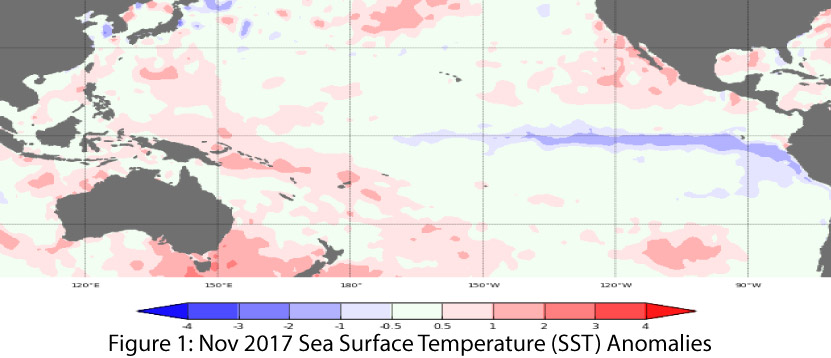
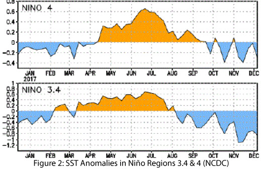
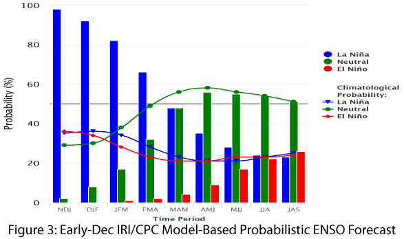
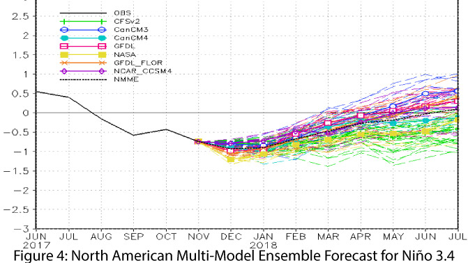
After a relatively late start, La Niña has ramped up over the past 30 days in terms of observed conditions and projected intensity, with sea-surface temperatures (SSTs) demonstrating a more consistent La Niña pattern (Figs. 1-2). Current forecasts and outlooks suggest a weak-to-moderate La Niña event lasting through the winter. On Dec. 11, the Japanese Meteorological Agency (JMA) identified ongoing La Niña conditions and called for a 60-percent chance of these conditions persisting until spring 2018. On Dec. 14, the NOAA Climate Prediction Center (CPC) extended its La Niña advisory, identifying an 80-percent chance of La Niña conditions lasting through the winter, with a likely transition to ENSO-neutral in the spring. The CPC forecast consensus identified La Niña conditions in the sea-surface and sub-surface temperatures as well as in atmospheric patterns. On Dec. 19, the Australian Bureau of Meteorology updated its ENSO tracker to reflect the emergence of La Niña conditions, but noted that this event was “expected to be short-lived.” On Dec. 19, the International Research Institute (IRI) issued its December ENSO quick look, calling for La Niña to last into the spring (Fig. 3), most likely as a weak event, but with the possibility of increasing to moderate strength. The North American Multi-Model Ensemble (NMME) is consistently indicative of a La Niña event of weak to moderate intensity this winter (Fig. 4).
Summary: The seasonal outlooks converged on a forecast for La Niña to last through the winter based on consistent La Niña patterns observed in both oceanic and atmospheric indicators. The intensity of the event is still under consideration, with a weak event the most likely scenario, but with increasing possibility of a moderate event mainly due to models and forecasts nudging towards the moderate threshold in the past month. Given the warmer- and drier-than-average winter conditions associated with La Niña in the Southwest, its presence may heighten ongoing concerns regarding winter precipitation and persistent drought. Southwestern winters are already relatively dry, however, so the emergence of a La Niña doesn’t necessarily ensure an exceptionally dry winter, it just takes wetter-than-average winters off the table based on past La Niña events. If the La Niña strengthens to moderate intensity, the likelihood of an even drier Southwest winter increases (see following page for a few examples).
Online Resources / Image Credits
- Figure 1 - Australian Bureau of Meteorology - www.bom.gov.au/climate/enso
- Figure 2 - NOAA - Climate Prediction Center - www.cpc.ncep.noaa.gov
- Figure 3 - International Research Institute for Climate and Society - www.iri.columbia.edu
- Figure 4 - NOAA - Climate Prediction Center - www.cpc.ncep.noaa.gov