The Southwest Monsoon Under Climate Change: What the Models Tell (and Don’t Tell) Us
Now that we (hopefully) have a better understanding of how climate models make long-term, generalized projections, can we use them to model our monsoon to figure out how it might be different under global climate change? The answer is yes and no, and that has to do with scale. To understand that, we first need to consider how the monsoon works.
Every spring and summer, a large subtropical high-pressure system called the Bermuda High (which is, by the way, responsible for gorgeous weather in–you got it–Bermuda!) spreads out across the southern United States. This large high-pressure system starts to circulate mid- to upper-level moisture around it, and into our region.
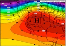
Figure 1: The upper-level Bermuda High extending to the west in July, when our monsoon begins. The red colors are higher pressures; the center of the Bermuda High is marked by an 'H'. This image is from the National Weather Service.
At the same time, it gets pretty hot in southern Arizona and New Mexico. This hot air rises, and as it does, it draws in moist air from the Gulf of California and Gulf of Mexico. Once a sufficient amount of moisture is present, thunderstorms can start.

Figure 2: The major features of the North American monsoon. The center of the high pressure system is again shown with an “H”. Moisture from the Gulf of Mexico is largely at upper- and mid-levels of the atmosphere, whereas moisture moving up the Gulf of California is a lower levels of the atmosphere. This image is from the UA College of Agriculture and Life Sciences: Climate Science Application Program.
These are all relatively large-scale events, but anyone who has lived here long enough knows that individual monsoon thunderstorms usually pop up over the mountains during the day and grow from there – a much smaller-scale process. This is because mountains heat up faster relative to the surrounding air, and in so doing they draw air from lower elevations up their sides. As the air rises, it cools and forms convective clouds; these may grow into thunderstorms if the conditions are just right. Representing this process accurately in an atmospheric model requires a relatively fine spatial scale, on the order of several kilometers. (Real-time monsoon forecasts at the University of Arizona are produced with a spatial scale of 1.8 km!) Such a fine scale is sufficient to resolve individual thunderstorms within a weather model simulation—and has resulted in much improved monsoon forecasts for southern Arizona. But a single thunderstorm is too small for a global climate model to pick up, as global models typically cover the entire state of Arizona with just four grid points – four points to represent all of Arizona’s interesting weather!

Figure 3: Monsoon precipitation as predicted by the models run for the IPCC 4th Assessment Report. The black line is observations, and the colored lines are the various model runs. This figure shows precipitation amount by month (1 is January, 2 is February, etc). Note that the precipitation amount and timing is not well captured by the models. This figure is from Lin, et al. 2008, J Climate.
To improve monsoon projections for the future, one way is to "downscale" (back to the issue of scale!), or create finer spatial information from a global climate model. When downscaling is performed using a regional atmospheric model, the monsoon can be reasonably represented. Such work is currently underway at the University of Arizona and elsewhere and the preliminary results have been quite promising.
So what's the bottom line?
Ok, what will happen with global warming? If it gets hotter, will the whole monsoon system become stronger? Will it get drier because of other atmospheric changes? Or will something else happen?
Well, the 2009 monsoon was a bust. We were all very excited about it, and it started strong, but by mid-July, an El Niño event in the Pacific changed the dynamics of the atmosphere enough that the large-scale features responsible and necessary for our monsoon didn't quite work out. If El Niño strengthens or becomes more frequent in the future, as some models predict, we could begin to see our monsoon weaken significantly. On the other hand, as the jet stream shifts poleward (as recent research suggests), we could see the monsoon subtropical high pressure system develop sooner in the year, making the monsoon longer and/or stronger. Or there might be another aspect of our climate system that is changing that will affect the monsoon in yet another way.
This is pretty indecisive, isn’t it? Well, that's why this is an area of active research. Climate modelers will keep working on this, atmospheric scientists will work on downscaling the models to be even more accurate, paleoclimatologists will keep reconstructing past climate of the monsoon to see how it varied when conditions were warmer, and soon we'll have a better idea of what to expect. In the mean time, stay tuned. At the very least, the weather will continue to be...interesting...
Sarah Truebe is a PhD candidate in the Geosciences Department at the University of Arizona studying paleoclimatology and the North American monsoon. She would like to thank Jonathan Overpeck and Christopher Castro for helpful comments and suggestions on this posting.