Southwest Climate Outlook - El Niño Tracker - January 2020
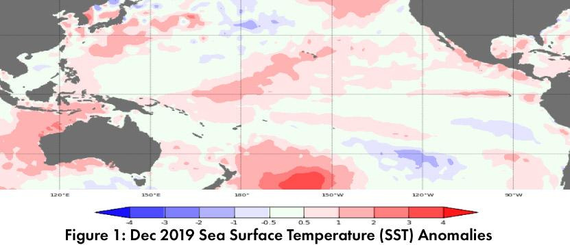
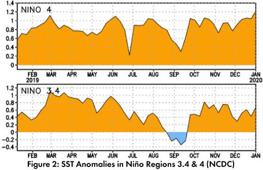
Warm waters continue to linger in the equatorial Pacific (Figs. 1-2), and while sea surface temperatures (SSTs) are expected to fall back within the range of ENSO-neutral, some forecasters made note of these warm conditions as something to keep an eye on in 2020.
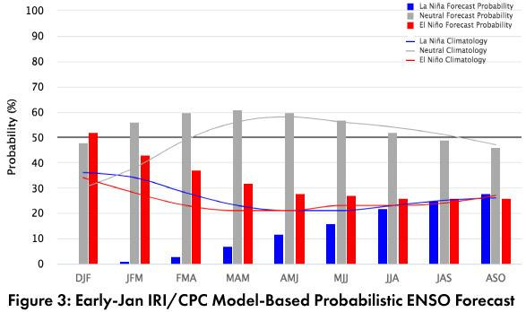
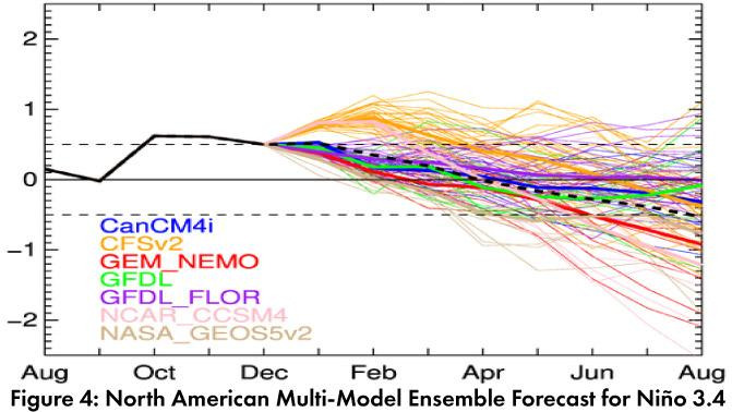
Forecast Roundup: On Jan 7, the Australian Bureau of Meteorology noted “the tropical ocean…remains warmer than average” but that ENSO indicators remained consistent with neutral conditions. On Jan 9, the NOAA Climate Prediction Center (CPC) issued their ENSO diagnostic discussion with an inactive alert status and called for a 60-percent chance of ENSO-neutral through spring and a 50-percent chance of ENSO-neutral lasting through summer. They stated “the oceanic and atmospheric system was consistent with ENSO-neutral, though recent observations reflected a trend toward warmer conditions that will be monitored.” On Jan 9, the International Research Institute (IRI) issued an ENSO Quick Look noting that despite recent above normal SSTs that were likely to last for another month or so, they would not last long enough to meet the criteria for an El Niño event. They maintained a 60-percent chance of neutral conditions through spring (Fig. 3). On Jan 10, the Japanese Meteorological Agency (JMA) maintained their call for a 60-percent chance of ENSO-neutral conditions to continue until spring 2020. The Jan 2020 North American Multi-Model Ensemble (NMME) shows positive SST anomalies into January, but is predicted to return and remain within the range of ENSO-neutral in February (Fig. 4).
Summary: Recent positive SST anomalies in the equatorial Pacific have been attributed to seasonal variability and not the return of El Niño. This appears to still be the case, with forecast consensus on ENSO-neutral conditions lasting into mid-2020. Most recent forecast discussions emphasized that these positive SST anomalies were large enough, but would not last long enough to meet the El Niño criteria, not to mention a lack of atmospheric coupling that is characteristic of El Niño events. A few agencies made note of warm oceanic conditions lasting longer than expected, but so far, all still see ENSO-neutral as the most likely outcome. In the Southwest, ENSO-neutral winters have produced some of the wettest and driest winters (and everything in between). We continue to monitor sub-seasonal and short term forecasts for insight into upcoming events. Given recent and long-term drought conditions in the Southwest, and regardless of ENSO status, a sustained run of regular precipitation events spread out over the cool season would be most welcome.
Online Resources
- Figure 1 - Australian Bureau of Meteorology - bom.gov.au/climate/enso
- Figure 2 - NOAA - Climate Prediction Center - cpc.ncep.noaa.gov
- Figure 3 - International Research Institute for Climate and Society - iri.columbia.edu
- Figure 4 - NOAA - Climate Prediction Center - cpc.ncep.noaa.gov