Southwest Climate Outlook - El Niño Tracker - February 2020
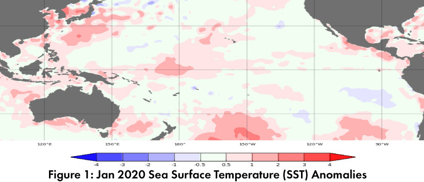
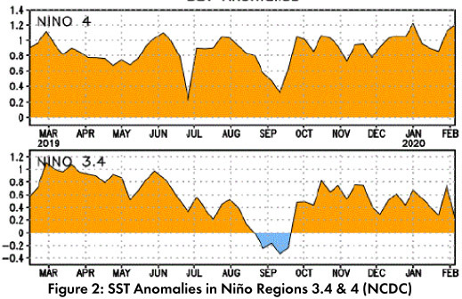
Positive sea surface temperature (SST) anomalies persisted in the equatorial Pacific, particularly in the western regions (Figs. 1-2). Despite these lingering warm waters, SSTs are expected to remain within the range of ENSO-neutral at longer timescales.
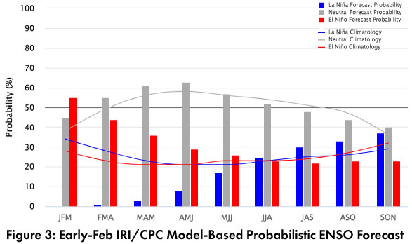
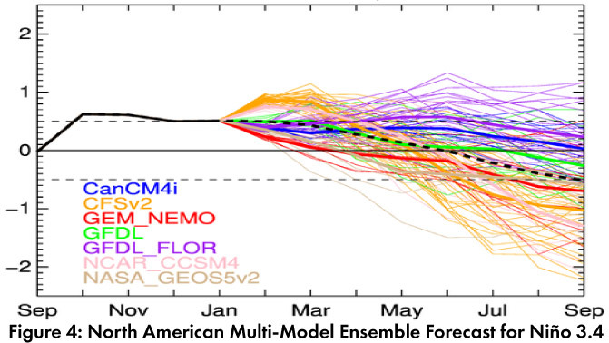
Forecast Roundup: On Feb 4, the Australian Bureau of Meteorology maintained their ENSO outlook at an inactive status, seeing “little or no sign of El Niño or La Niña developing in the coming months.” On Feb 10, the Japanese Meteorological Agency (JMA) maintained their call for a 60-percent chance of ENSO-neutral conditions to last until summer 2020. On Feb 13, the NOAA Climate Prediction Center (CPC) issued their ENSO diagnostic discussion with an inactive alert status. The CPC maintained their call for a 60-percent chance of ENSO-neutral through spring 2020 and a 50-percent chance of neutral lasting through summer. They highlighted that while SSTs were near the El Niño threshold in the short term, the longer-term outlook pointed towards oceanic and atmospheric conditions consistent with ENSO-neutral. On Feb 13, the International Research Institute (IRI) issued an ENSO Quick Look (Fig. 3), noting that “borderline weak El Niño” SSTs were present and forecast to last through winter 2020, but “returning to ENSO-neutral by spring and beyond.” The Feb 2020 North American Multi-Model Ensemble (NMME) shows another month of positive SST anomalies on the border between neutral and El Niño, but is predicted to return and remain within the range of ENSO-neutral in Mar/Apr 2020 (Fig. 4).
Summary: Over the last month, we have seen another run of positive SST anomalies that are near the El Niño threshold, but none of the forecasts see much chance of an El Niño event…why? A quick reminder that while the warm oceanic conditions may be present and in the range of weak El Niño thresholds, to be considered an El Niño event, the three-month average would need to stay above this threshold for five consecutive months. The atmosphere would also need to cooperate (often called ‘oceanic-atmospheric coupling’). The more nuanced forecast discussions have focused on the fact that these positive SST anomalies are unlikely to last long enough to meet the El Niño criteria, as well as the lack of atmospheric conditions, and ENSO-neutral remains by far the most likely outcome. In the Southwest, ENSO-neutral winters have produced some of the wettest and driest winters (and everything in between). We continue to monitor sub-seasonal and short term forecasts for insight into upcoming events.
Online Resources
- Figure 1 - Australian Bureau of Meteorology - bom.gov.au/climate/enso
- Figure 2 - NOAA - Climate Prediction Center - cpc.ncep.noaa.gov
- Figure 3 - International Research Institute for Climate and Society - iri.columbia.edu
- Figure 4 - NOAA - Climate Prediction Center - cpc.ncep.noaa.gov